You are here: Homepage » Attachments HH-Plan 2026
You are here: Homepage » Attachments HH-Plan 2026
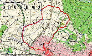
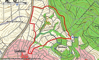
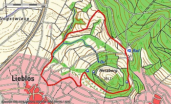
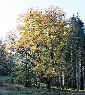
Gründau, the community in the green, that's the slogan.
Anyone who sets out to get to know the community better will soon come to the same conclusion.
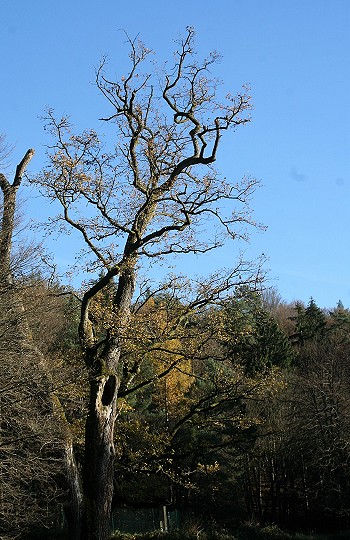
Nearly half of the municipal area is forest, and the vast open fields also invite you to take walks, hikes, and bike tours.
The route often leads past historical buildings, offering insights into the history and culture of our homeland.
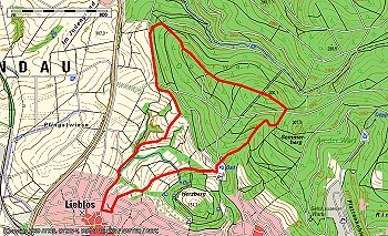
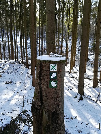
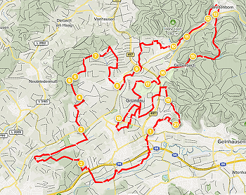
The municipality of Gründau has marked circular hiking trails. Thanks to clearly visible trail markers, hikers are guided back to their starting point. All trails are shown on the hiking map „Unteres Kinzigtal/ Ronneburger Hügelland“ by Rheingau-Taunus-Kartographie.
Volunteers regularly check the signage of all trails to ensure that you as a guest have an unimpeded hiking experience.
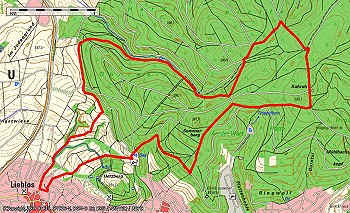
„Owl“ hiking trail“
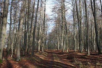
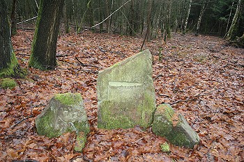
The longest of the Lieblos hiking trails is marked with an owl. You should plan about three hours for the almost eleven kilometers. The butterfly trail leads to the Sommerberg to „Lothar's Bank,“ and the Schnepfenweg trail, which starts at Gettenbach pond, leads to the „Gelnhäuser Tor.“ There, you enter the former princely forest. Through old beech stands, you reach the next gate, where you re-enter the Gelnhäuser town forest. At Kuhruh, where the Gelnhäuser singers used to celebrate May Day, go downhill to the Grenzweg. Turn right there, and you will soon reach the „Stone Table,“ where traveling merchants could conveniently place their baskets to rest. Then you meet the butterfly trail again, which leads to the forest swimming pool, and from there, continue with the wild boar and woodpecker trails back to the starting point.
„Fox“ hiking trail“
The only hiking trail in Lieblos is marked with a fox, which also runs west of the federal highway. Allow one hour for the approximately five-kilometer hike. After an ascent from the playground on Sommerbergstraße to the edge of the forest, the Fuchsweg (Fox Trail) meets the Jakobsweg (Pilgrim's Way), which it follows for a while. A stone with the symbol of the pilgrimage route to Santiago de Compostela can also be found there. Briefly along the forest, it soon turns left through a hollow path to the bike path on the federal highway. Turn right and then left through the underpass in the valley, which was painted for the 40th anniversary of the municipality of Gründau and commemorates the town twinning with the French Laussonne, the Jakobsweg, and the anniversary. Shortly before the airfield of the model aircraft club Ikarus, turn left up the hill to a cozy bench. The Jakobsweg turns right towards the mountain church, while the Fuchsweg leads the hiker across the Pfingstwiese (Pentecost Meadow) to the Heinrichshof, a large riding stable, which is passed through in the direction of the cemetery. Through an underpass equipped with heavy floodgates, you enter the Lieblos district. Following Rötestraße, you reach Zeister Straße. Follow it to the clubhouse of Einigkeit Lieblos and turn left. Cross the street diagonally to reach the old Büdinger Straße, which you follow past the hotel „Zum Euro“ to Tiergartenstraße. Turning right leads you back to the starting point.

„Butterfly“ hiking trail“
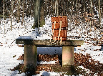
Allow a good two hours for the butterfly trail, which is just over eight kilometers long. Together with the owl trail, it passes close to the Hühnerhof golf course and circles around the Oberwald. At „Lothar's Bench,“ it leaves the owl trail, only to rejoin it a few meters downhill. „Lothar's Bench“ was donated to Oberamtsrat Lothar Krieg by the city of Gelnhausen upon his retirement. He was responsible for the Gelnhausen city forest for many years. Together, the trails lead past the large solar farm at the Gelnhausen Watchtower, to the forest swimming pool, and return to Sommerbergstraße via the Milan trail.
„Wild Boar“ Hiking Trail“
The Keilerweg is approximately four and a half kilometers long and takes a little over an hour to complete. After the water reservoir above Sommerbergstraße, it's the only path that branches off to the left into the field. Behind a large machine hall, it turns left towards the federal highway. There, a bench invites you to rest. The path continues a short distance along the road, then at the crest, it turns right into a hollow path. This path leads up into the forest. After about 200 meters in the forest, the Keilerweg turns right onto a charming forest path, which you follow to the Gelnhausen city forest kindergarten. At the forest swimming pool, the Keiler meets the Specht and Eule (woodpecker and owl), with whom it goes north around the Herzberg back to the starting point.
„Milan“ Hiking Trail“
The shortest of the circular hiking trails in Lieblos is marked with a red kite. The nearly four kilometers around Herzberg can be covered in about an hour. From the starting point on Sommerbergstraße, the path ascends along with the fox, woodpecker, butterfly, and owl trails to the „Fahrstraße“ at the edge of the forest. There, the red kite trail turns right, leading along the forest edge to the former forest swimming pool in Roth. At the lower end of the swimming pool grounds, turn right onto the street „Auf dem Herzberg“ and, together with the butterfly trail, return to Lieblos below the restaurant „Paradies“. Here, you can still see the remains of some walls in the forest above, which terraced the vineyard there. Until the end of the 19th century, almost the entire Herzberg was a vineyard. Only the introduced phylloxera put an end to it. The former Lieblos quarry is also located on Herzberg. Until the 1950s, it was used for large festivals and even hosted an open-air stage. After frost damage caused some stones to fall, destroying the changing rooms among other things, the quarry was closed to the public. After a short walk through the village, you reach the starting point again.
„Woodpecker“ Hiking Trail“
A woodpecker marks a circular trail approximately six kilometers long, which takes about one and a half hours. It first follows the owl and butterfly markings until just before the chicken farm. Then the path leads through the middle of the Oberwald forest to the Sommerberg. From there, it descends steeply to the forest swimming pool and then continues with the owl and boar markings back to Sommerbergstraße.
„Eagle Owl“ hiking trail“
A flat, circular hiking trail approximately one and a half kilometers long starts at the hiking portal at Hasselweiher near Reitzeberg, close to Mittel-Gründau. It takes about half an hour to complete. The trail is marked with a white eagle owl on a green background.
The Hasselweiher was created in 1974 and ’75 by Erich Hahn, based on historical models and his own ideas. A memorial plaque for him is located directly next to the hiking portal. The pond is dominated by a central island with a duck house. Particularly striking are straw tubes mounted on iron poles far above the water surface. These are so-called „South Dakota Hen Houses.“ With them, Tobias Hess, the tenant of the pond, wants to offer local garganeys and mallards safe nesting opportunities. There they can be undisturbed by invasive Egyptian geese or the ubiquitous raccoons introduced from the USA.
„Wild Boar“ Hiking Trail“
The middle of the three hiking trails starting at Hasselweiher is marked with a wild boar, has a route of just over four kilometers, and can be completed in a little over an hour. Between Hasselweiher and the forest, you enter the Ronneburger Wald and constantly climb uphill to Hasenkopf. At the end, turn left and descend a winding path past Steinkopf and Rabennest, then turn left again. You will leave the forest and return to Hasselweiher via a panoramic trail above Almessengrund. Almessengrund derives its name from "Almosen" (alms) and was farmed in earlier times by nuns from the Arnsburg monastery, which operated a large farm here.
„Woodpecker“ Hiking Trail“
The longest of the circular hiking trails from the hiking portal at the Mittel-Gründau Hasselweiher is marked with a white woodpecker on a green background. It is approximately seven kilometers long and leads to Ronneburg. The hiking time is just under two hours. Between Hasselweiher and the edge of the forest, you enter the Ronneburg forest, turn right immediately, and ascend a long, gentle slope past Hasenkopf. At the edge of the forest, you see Ronneburg, which suddenly appears almost at your feet. Here, a bench invites you to rest. Turning left, you walk along the edge of the forest around Steinkopf. After passing through the forest at Sauerngrund, you turn right and leave it via a panoramic path towards the settlement of Steinbach. Before the first house, you pass a small grove to Hardtwegshof. In the grove is the Rodenborn spring. It gave its name to a nearby settlement, which, however, disappeared from maps at the end of the 15th century. Through Almessengrund, you then turn left over a hill back to the starting point.
„Mushroom“ hiking trail“
A mushroom marks the shortest of the hiking trails from the parking lot at the eastern end of Gettenbach. The trail is just over two kilometers long and can be completed in about half an hour.
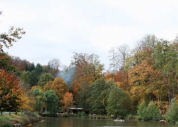
Once you pass through the forest gate, you will soon reach the former festival grounds, where the Gettenbach fire department held its big May Day celebration until 2018. On the left side, there is an electrical box and next to it, a manhole cover. The Gettenbach is artificially fed with five liters of groundwater per second from the adjacent well A. Directly above is the „Tontaubenweiher“ (Clay Pigeon Pond), the last of seven former fish ponds built in the 1970s in the Gettenbach valley. To the left of the pond, the path runs along the dry Gettenbach first to the Karlshütte and then continues to the former spring. The spring source is dry on the left side behind the wildlife fence. Groundwater is also being fed into the pipe that used to carry water under the path. A rate of 30 liters per minute is specified to maintain the amphibian biotope in the spring area. None of this water reaches the lower Gettenbach.
A few meters further on, there are some very old, imposing oaks, and in front of one, designated as a natural monument, is a memorial stone. It was erected by forest officials for Count Karl of Ysenburg and Büdingen-Meerholz, who shot his last stag there on October 16, 1699. On the other side of the pond, the path leads back to the parking lot.
„Stag Beetle“ Hiking Trail“
A roughly five-kilometer hiking trail marked with a stag beetle on a green background leads from the hiking portal. The trail can be walked in about an hour and a half.
Through the game fence, it leads into the forest to the pond. There, immediately to the left, next to the pump house, you'll find a gate. Through this gate, you go straight uphill. Turning left at a large forest meadow, you reach the former game fence on Köhlerkopf. The large area was cleared in the thirties to create arable land to supply the citizens of Gettenbach.
A little further to the left, in the forest at „Franzosenhau,“ lies the memorial stone for forester Heinrich Nieß, who was killed by poachers. To the right, past the large meadow, turn right at the end. After a while, you will pass a boundary stone with the number 18. This was placed by the prince to demarcate the northern and southern Gettenbach forest districts from each other. At Strackerschneise, the direct path, turn right and descend again through Altenjagen, reaching the gate at the pump house. You return to the parking lot via the same route you came.
„Schnepfe“ Hiking Trail“
The circular hiking trail, marked with a white snipe on a green background, leads approximately seven kilometers in an figure-eight shape into the Gelnhäuser town forest. The hike can be completed in under two hours.
Starting from the parking lot at the edge of Gettenbach, the path immediately climbs uphill to the right after passing through the game fence. A long ascent up to the Kohlplatte leads to a crossroads, which the path will encounter again later. Continuing straight ahead, you'll reach a game fence where you leave the former princely forest and enter the Gelnhäuser Stadtwald (city forest). Passing the Prenzelseiche (oak tree), you reach the „Kuhruh“ shelter. Here, the path turns right and, with a slight descent, reaches „Lothars Bank,“ which serves as the ideal resting point. From there, head downhill a few meters to the north and then immediately right. After some time, you'll find the „Gelnhäuser Tor“ on your left, through which you re-enter the fenced Gettenbacher Wald. Turning right again, the Schnepfenweg leads through a beech-dominated forest to the previously visited crossroads. There, turn left downhill until you reach the game fence, where you turn right and soon pass through a gate to reach the parking lot again.
„Squirrel“ Trail“
A roughly seven-kilometer circular trail marked with a squirrel symbol takes about two hours to complete. With two steeper ascents, it is somewhat more challenging.
Through the forest gate at the edge of Gettenbach, you go straight through the so-called „Judenschneise“ (Jewish clearing) over the Schultheißenkopf. Local historian Heinrich-Georg Semmel believes the Judenschneise to be the moderate ascent to the Rennstraße, which heavily laden Jewish merchants are said to have used from Gettenbach. At a large intersection, you reach the Rennweg, a historic fast connection between Wächtersbach and Büdingen. There, however, you immediately turn right at the first bend, going back down into the Schulgrund, actually Schorlgrund, as there were many springs there from which lightly sparkling water bubbled. These have all dried up in the meantime. Upon reaching the bottom, you turn right and immediately take the next path on the left up to the Glashüttenkopf. At the top, you reach a long row of stately oak trees, which you follow to the right until the next intersection. From there, you go steeply downhill to the right back to the pond and left back to the parking lot.
„Antler“ hiking trail“
The longest hiking trail from the Gettenbach parking lot is marked with a stag's antlers on a green background. The nearly nine-kilometer route can be completed in about two and a half hours.
Immediately after the game fence, turn left before the pond and go through the gate at the pump house. The path leads straight uphill past a large forest meadow at Köhlerkopf to a large intersection on the crest. Turn right onto Rennstraße, past Winkelhalle, to another intersection. Shortly thereafter, turn halfway right through a dense spruce forest. As soon as the forest thins out again, you will find a wooden cross on the left, commemorating Karl Kalmbach. Then a pleasant path leads through the „Kessel“ to a T-intersection. Here, go right downhill through the Schulgrund, passing between Schultheißenkopf on the right and Glashüttenkopf on the left, and back past the pond to the parking lot.
„Maple“ hiking trail“
The maple leaf marks the longer of the two municipal hiking trails leading from the chicken farm in Gettenbach, titled „Rund um den Golfplatz“ (Around the Golf Course). The trail is approximately seven kilometers long and can be easily completed in two hours. From the parking lot, you proceed along the farm building to the St. Francis Chapel. The chapel was donated in 2002 by the Hecker family, who operate the chicken farm, and dedicated to Saint Francis, the patron saint of animals, thereby underscoring the Heckers' ecological commitment.
The path continues across the golf course, past a Kneipp facility that is open to all visitors. It then proceeds through a barrier into the forest and constantly uphill, along a small stream that bears the imposing name „Hühnerfluß“ on old maps. At the first pond in the valley, you'll have completed about half of the ascent. Our hiking trail runs parallel to the VHC hiking trail „Burgenpfad“ along this section, which is marked with a green St. Andrew's Cross. Both paths turn off at the next pond and cross the valley. The charming pond invites you to linger. After a very short climb, you reach a well-maintained path where the trails to the left turn uphill towards Gelnhausen. Turning right would lead you to the Hühnerhof after about four kilometers. Once at the top, you reach „Lothar's Bank,“ a place to rest, and turn right. At a T-junction, a steeply descending path named „Bunkerstraße“ branches off to the left, leading to the Röther Wald swimming pool.
However, „Ahornweg“ continues straight ahead to the edge of the forest. On the right at the edge of the forest, some benches are offered, from which you can let your gaze wander to the Frankfurt skyline. On the next path to the right through the forest, you reach the golf course again. This section also features many maple trees, which give the path its name.
„Oak Leaf“ Hiking Trail“
The oak leaf marks the shorter of the two „Around the Golf Course“ routes. The trail is about six and a half kilometers long and can be completed in a good hour and a half.
The first section of the trail runs parallel to the previously described Ahornweg. After the pond, however, it follows the VHC trail to the left until just before the summit and then turns left onto the VHC trail „Barbarossaweg“ with a green cross and the Stolberg-Ysenburg-Weg, marked with two white bars on a black background. The Hessenweg No. 2, also called „Barbarossaweg,“ runs parallel to it. At the summit, „Lothar's Bench“ invites you to linger.
It continues to a passage through the wildlife fence, known as the „Gelnhäuser Tor.“ Immediately after, you turn left and then immediately right over the „Hardt“ and soon after turn left downhill again towards Gettenbach. On the left side, you'll find a door leading into an old civil defense bunker. Shortly thereafter, you pass another gate and leave the former princely forest. Upon reaching the entrance to Gettenbach, the Eichblatt trail leads us back along the bike path to the starting point of the hike. At the Hühnerhof, the Gutsschänke [estate tavern] invites you for refreshments. In the courtyard of the estate, the hotel operates a café and serves delicious homemade cakes.
Hiking trail „Chicken Trail“
A ten-kilometer hike leads between Gettenbach, Hain- and Mittelgründau around the Stickelsberg, as the current 18-hole golf course was named on historical maps. We start the hike in the parking lot of Gut Hühnerhof. Other entry points are available at the parking lots at Hain-Grünaus Laurentiuskirche, from the restaurant „Heckers,“ or from the Mittel-Gründau train station. The trail is marked in both directions with a red chicken on a white background and can be hiked in just over two hours.
On the north side of the historic estate is the „Swiss House,“ where the milkmaids (from Switzerland) once lived. The path also crosses the old border between the Grand Duchy of Hesse and the Electorate of Hesse, where the actual estate was located. One story says that a corpse was dragged across the border to be brought to justice by the other ruling authority. The estate building is left behind on the right. From the parking lot, you proceed along the hotel to the Francis Chapel. The chapel was donated in 2002 by the Hecker family, who run the chicken farm, and dedicated to Saint Francis, the patron saint of animals, thus underscoring the Heckers' ecological mindset. You continue across the golf course, with the first public Kneipp facility, built by the Hecker family, on your left. After traversing the 9-hole golf course, you reach a barrier, before which you turn right. Follow this path to the end and then turn left along the edge of the forest.
Here, the hiker is greeted by the „Skyline View,“ a wonderful vista of Frankfurt's skyscrapers. Next to it, the „Ginnheim Asparagus“ (a distinctive TV tower) can be clearly seen, along with the Taunus mountain ranges. Further to the left, the view encompasses the Hanau „Staudinger“ power plant. Benches are placed at this height for rest. The next asphalt path to the right runs parallel to the Way of St. James, marked by a yellow scallop shell on a blue background. Through a hollow way, you reach the cycle path along the B 457. Going right and down leads to the underpass, allowing safe crossing of the federal highway. At the second intersection, the Way of St. James turns off. Continuing straight ahead, you pass the MBC Ikarus model aircraft field and arrive at a tranquil pond at the foot of the golf course.
The path continues uphill, past the railway crossing, to the mountain farms, around the historic „Stickelsberg“. Shortly thereafter, you reach the restaurant „Heckers“. There you have the opportunity to stop for refreshments. With the large parking lot, it also offers the chance to start your hike here and end it at the restaurant. Directly on the path, the Hecker family has built another public Kneipp facility, where hikers can cool their tired feet. For those who are not yet tired enough, a visit to the adventure golf course or the barefoot path can be planned.
Continue to the ADAC grounds and then turn left along the fence. The path leads past the Talhof to a small bridge over the Gründau river. From there, it's a good entry point for hikers arriving by train. After the bridge, turn left. Over the next narrow bridge, you'll reach the Mittel-Gründau train station via a narrow path. Turn right at the bridge, which leads to the ponds of ASV Gründau. There's also an opportunity to stop for refreshments, though currently only on Mondays, Tuesdays, and Fridays from 2 PM to 7 PM. From the angler's home, you can already see the next underpass to get back to the other side of the federal highway. Shortly thereafter, the path reaches the Laurentius Church.
The Protestant church dedicated to St. Lawrence was built in 1715. It is particularly striking for its simplicity, with a double gallery that makes it appear much larger inside than it does from the outside.
Starting from the church, cross the Gründau river on an old bridge, take the next left turn, and then immediately right again. Here, you'll follow a small stream, which on historical maps bears the grand name „Hühnerfluß“ (Chicken River), until you reach the bypass road at the bus stop and return to the Hühnerhof. The farm tavern and hotel café invite you to rest. You'll also find a mini-golf course here.
A shortcut is available between the Gut Hühnerhof and Restaurant „Heckers“ stations. The path leads from the estate along the bike path to a traffic light where the federal road is crossed. Then, turn left, along the ADAC grounds up to the restaurant on the hill. The valley traversed has the historical name „Judengrund.“ The direct path is marked with a white chicken on a red background. This also offers the possibility of walking only the northern or only the southern route, each about seven kilometers long. This takes about one and a half hours.
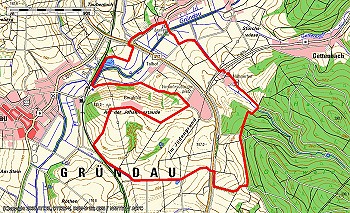
This is the hiking route developed by Hannes Schulz for the 50th anniversary of Gründau 1972-2022, with the working title Gründau50. It goes once around the municipal area, taking into account all 7 districts.
The trail is intended for individual hikers and/or groups. Experienced hikers can complete this route in about 10 to 12 hours.
From Lieblos, it goes through the Kinzigaue around Rothenbergen to the south. The path then leads north through the Steinbach residential park to the Hasselweiher at Reitzeberg. Across the Mittel-Gründau district, it follows the Gründau, the stream that gave the municipality its name. Past the Angelweiher pond, it reaches the edge of the Büdinger Wald on Hain-Gründau territory. Through Hain-Gründau, one follows the Gründau to Breitenborn. In this area, it is still called Litterbach. Once through Breitenborn and up into the forest, it continues over the Eichelkopf to the Gettenbach district.
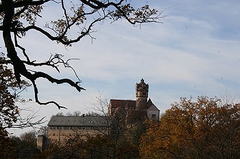
You cross the smallest district of Gründau completely from east to west. Continue past the golf course through the fields up to the Bergkirche in Niedergründau. Continue past the composting plant through the fields back towards the federal road. You cross this at an underpass, which is decorated with murals commemorating Gründau's 40th anniversary as a municipality and the Way of St. James. Along the edge of the forest, you then reach Lieblos again. Passing the Herzberg and Sommerberg, you then head back to the starting point.
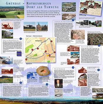
Experience the history and present of your hometown together – hikes on the European cultural trail Rothenbergen.
Since September 2012, a „European Cultural Route Rothenbergen“ has been established.
On the roughly six-kilometer circular trail through the district and the Rothenbergen district, seven information boards provide details on history, nature, and landscape.
The hikes always start in front of the restaurant „Alte Wache“ in Rothenbergen, last about two and a half hours, and end at the country inn „Zum Bogen“.
Information about the history of Rothenbergen can also be found in the book „Von Rodinberch bis Rothenbergen – Geschichte und Geschichten aus dem Dorf an der Straße“ by Martin Ludwig and Peter Völker, as well as in the accompanying map, which can be purchased in Rothenbergen at the „Zum Bogen“ country inn, Schnell's hair salon, and the post office.
The book, which illuminates history from the Stone Age to the cusp of the present day, costs 19.30 Euros, and the map for the book costs 5 Euros.
The concept of cultural paths, developed within the EU project "European Cultural Paths," is designed to span across regions – from Mainfranken to the Vogelsberg and from Frankfurt to Würzburg. These cultural paths highlight and showcase the cultural landscape's unique features in individual municipalities and urban or rural districts, which have largely remained unknown until now.
You offer a new perspective on your respective home village, according to Dr. Gerrit Himmelsbach, project manager of the Archaeological Spessart Project (ASP).
Brochure for the cultural trail available at the municipal administration.
Contact: lehrer-ludwig@t-online.de, voelkerpg@aol.com
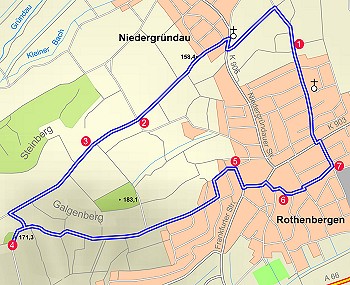
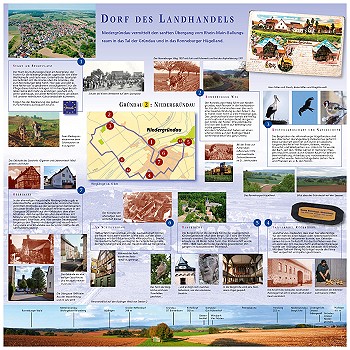
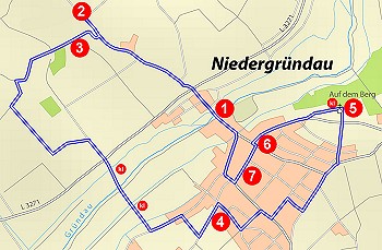
Experiencing the history and present of one's hometown together – Hikes on the European Cultural Trail Niedergründau – Village of Farmers' Markets
A „European Cultural Path Niedergründau“ has been established since 2016.
Along the approximately six-kilometer circular trail through the district and the Niedergründau district, seven information boards provide details about history, nature, and the landscape.

Forms & Online Services
Appointment Scheduling

Waste & Disposal

Defect report

Current events
Forms & Online Services
Appointment Scheduling
Waste & Disposal
Defect report
Current events
The town hall is open today at the following times:
Then simply contact us anytime using the following contact options: